
The Power of Patagonia
 |
At the head of a remote fjord in southern Chile, a determined Norwegian named Samsing settled down in 1925 to a life of pasturing sheep in what was then a grass-filled valley. A year later he was literally chased out of his homestead by an advancing glacier.
Written by: Verlyn Klinkenborg
Photographs: Maria Stenzel
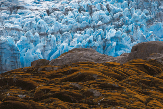
Where his estancia lay there is now a glacial lake with icebergs floating in it. The glacier, today called P5o XI, relented for a time, then went on the march again. Nowadays it is lifting a forest by its roots, flinging it ever so slowly aside. Along the capsizing tree line, Guaitecas cypresses, some hundreds of years old, seem to have paused even as they were toppling. Roots have been upturned, crowns snapped off, trunks set akimbo. Elephantine boulders of ice have been driven under moss and carnivorous bog plants.
The woodland PÝo XI is shoving aside is Magellanic rain forest – not the dark, canopy-rich rain forest of the tropics, but the kind of matted, windblown bonsai you see at tree line in the mountains. And no wonder. The fjords and islands of Chilean Patagonia take the brunt of the prevailing westerlies that wail across the southern seas. Here in the heart of the roaring forties, the wind can blow with almost constant ferocity. Rain and snow can fall all year round.
No place on the planet is fully at rest. Only time – unimaginable stretches of time that conceal from human eyes the dynamic natural forces shaping the Earth – creates the illusion of stasis. But sometimes, if you're lucky, you come upon a place where time seems compressed, where you can feel in your bones how kinetic even geology really is.
The glacier-carved coast of Chile is such a place. Here the Earth's energy seems almost palpable. Tectonic plates are spreading and then diving under this fringe of the continent, lifting the Andes and creating a geologically volatile zone. From the interior ice fields, glaciers such as PÝo XI – short, brutal rivers of ice – descend swiftly to the sea. Offshore, the upwelling of the Peru Current is a fountain of aquatic life. The shoreline, divided by a labyrinth of waters, stretches more than 50,000 miles. This Patagonia differs utterly from the one that name usually conjures – a land of broad pampas. This Patagonia belongs to sea and ice.
At the heart of this wild region lies Bernardo O'Higgins National Park. More than 200 miles from end to end, the park encompasses Patagonia's Southern Ice Field, which with its northern counterpart forms one of the largest expanses of glacial ice outside the polar regions.
There is no coming overland to Bernardo O'Higgins, and no flying in either. The only way in is by water, intricately, through a maze of deepwater fjords that ultimately leads to the snout of PÝo XI. There glacial thunder fills the air – cracking, resonant reports from deep in the ice field as well as duller but more profound detonations caused by the calving of bergs from PÝo's snout. Those explosions end with the hiss of new waterfalls and spilling ice shards. At the ragged seam where glacier meets rain forest, PÝo fills the sky, a mountain of ice towering toward the midday sun. Nearby, the glacier is almost cormorant black, then petrel gray. Farther off, higher up, the ice turns white and then a hundred impossible species of blue.
In this distant and extreme terrain, the fundamental story of our time is being told afresh. Here it is possible to see, with a clarifying starkness, how tightly woven our new world really is. As isolated as Chilean Patagonia is, it is also on the brink of abrupt transformation. On land the few homesteads look as though they were carved out of the 19th century. But there are plans to dam the wild rivers north of Bernardo O'Higgins. And clinging to the water's edge, there is the steady southward movement of salmon farms, a source of economic opportunity and an environmental plague. At the urging of conservationists, Chile has considered designating its ice fields and most of the protected areas along its southern coast as an enormous new UNESCO World Heritage site – millions of acres in all. But as of late 2009, the government was backing away from the ambitious plan in favor of a more modest proposal. Yet in its wild south, Chile still has the chance to preserve great tracts of a natural world that has barely begun to be explored, even as it is threatened by potentially devastating change.
On a map the seemingly endless archipelagoes in the Chilean fjords look like rubble that has spilled from the Andes. The main channels were charted early on – part of the search for a tolerable route around Cape Horn. Pedro Sarmiento de Gamboa worked his way into these waters as early as 1579. British navigator John Byron came to grief in 1741 on an island now named for his ship, the Wager – an epic tale of treacherous sailing and debilitating conditions. Darwin came here on the Beagle and noted that the sound of calving bergs "reverberates like the broadside of a man-of-war through the lonely channels."
Still, it's surprising just how recently even the most fundamental kinds of exploration were done. The English names that lie scattered across the map here were bestowed by a British surveying expedition in 1830. But PÝo XI was named in honor of Pope Pius XI by Father Alberto de Agostini, an Italian missionary and explorer who in 1931 was the first person to cross the Southern Ice Field. The town of Cochrane – just on the edge of the proposed United Nations reserve and now a center of controversial hydropower development – was founded in 1954 but was reached by road (a rough gravel track) only in 1988. When the first charts based on aerial surveys of Chilean Patagonia were published in 1954, one scientist called them "the biggest map revision in the Earth's geography to be made in modern times."
Yet even in 2007 the authors of a survey of glaciological studies felt compelled to point out a "serious gap in the observation of South American glaciers." It's safe to say that the interior regions of most of the protected areas along the fjords of Chilean Patagonia – Bernardo O'Higgins National Park, Katalalixar National Reserve, Las Guaitecas National Reserve, Laguna San Rafael National Park – are still utterly unknown. The forests are impassable, the footing knee-deep in moss and other low plants growing on a dense weave of branches and roots. They conform all too well to the experience of one observer who said in 1904, "The general wetness of these half-submerged islands quite surpasses all ordinary experience."
Change is invading by water. A few small cruise ships from Puerto Natales now make a run to the faces of several glaciers, where they gather ice for cocktails from small bergs drifting in the shadow of ice cliffs. The Navimag ferry churns its way from Puerto Natales to Puerto Montt – a four-day, one-way trip – stopping to exchange propane, produce and a few passengers in Puerto EdÚn. The Chilean Navy patrols these waters. CONAF – the Chilean version of the U.S. Forest Service – has assumed responsibility for protecting as well as exploiting the region.
Over the past century the indigenous inhabitants have dwindled. The rookery of seals that early explorers found at the entrance to Eyre Fjord, where PÝo XI terminates, is long gone. The whales of many species that frequented these fjords now barely make up a biological quorum. A red tide plagues the mussels that once sustained the fishing economy. The Alacaluf Indians, who once hunted and fished here, have dwindled to a handful of disconsolate souls in Puerto Eden, a place whose only Edenic quality is its distance from the rest of the world.
Distance is no protection these days. After Norway, Chile is the world's largest producer of farmed salmon, which are grown in podlike cages anchored offshore in Las Guaitecas National Reserve near the Northern Ice Field. (What is legally preserved in Guaitecas and other parks is the land, not the water.) The Norwegian companies that began salmon farming in Chile came here because the fjords were unspoiled. That is no longer the case. Like nearly every form of concentrated animal agriculture, salmon aquaculture creates an excess of waste. Here salmon farms deaden the water, creating anoxic conditions, and have led to the spread of a lethal salmon virus called infectious salmon anemia. The solution of the salmon-farming companies has simply been to move south into clean waters. Already the companies have taken out new leases on stretches of water throughout the southern fjords.
Meanwhile, on land, the threat comes from hydropower. Thanks to the Pinochet regime, most of the water rights on the major rivers that spill into the fjords are privately owned – and by foreign corporations, no less. For the past several years there has been increasing pressure to build a series of hydroelectric power dams along the Pascua and Baker Rivers. But critics argue that dams are antiquated and unnecessary in a country with such abundant renewable energy potential. They destroy the ecosystems of the watersheds in which they are built, and running transmission lines from these dams to Santiago will require a clear-cut more than a thousand miles long.
The gravest danger to the Chilean fjords is, of course, climate change, which threatens to alter the rivers that depend on these glaciers and upset the balance of salt and fresh water in the inner fjords. Of the 48 glaciers in the Southern Ice Field, 46 are retreating and one is stable. Only one, PÝo XI, is advancing. It is almost certainly the only glacier in the world at its neoglacial maximum – its farthest reach since the beginning of the Little Ice Age in Patagonia some 400 years ago.
PÝo is now uprooting trees that are several centuries old. No one knows for certain why it has advanced so far and so fast over the past 80 years. It may be recovering ground that was lost to eruptions of Lautaro, the active volcano from which the Southern Ice Field radiates. Or its advance may be due to the tectonic upheaval that is lifting the Andes, or to the volatility of a temperate glacier – its ice nearly always at the melting point – in a region of very high precipitation, 30 feet a year and more. But one thing is clear. PÝo XI is an anomaly in a melting icescape.
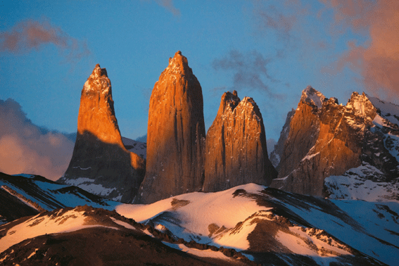
A hundred and thirty miles south of PÝo XI, in Torres del Paine National Park, tourists are bused in by the thousands. They camp in tent cities and queue to cross the mountain passes. They share a sense that this national park is unique and worth protecting. In the Chilean fjords, however, there will never be crowds. Their very remoteness puts them at risk, and not just from salmon farming and hydro dams. The risk is a lack of awareness, a forgetting that places as wild as Chilean Patagonia cannot survive without protection. Creating parks and reserves – even a UNESCO World Heritage site – may make a difference. But it may also be only a change in name.